 Here is another large pile from Carlisle that my friend from there showed me. It has been written about in the history of Carlisle as a town boundary marker, and so it is probably OK to say where it is located: down the Fielding Farm road on the right, just before the road crosses a bridge over a brook. The view above is to the north. Here is a view to the east.
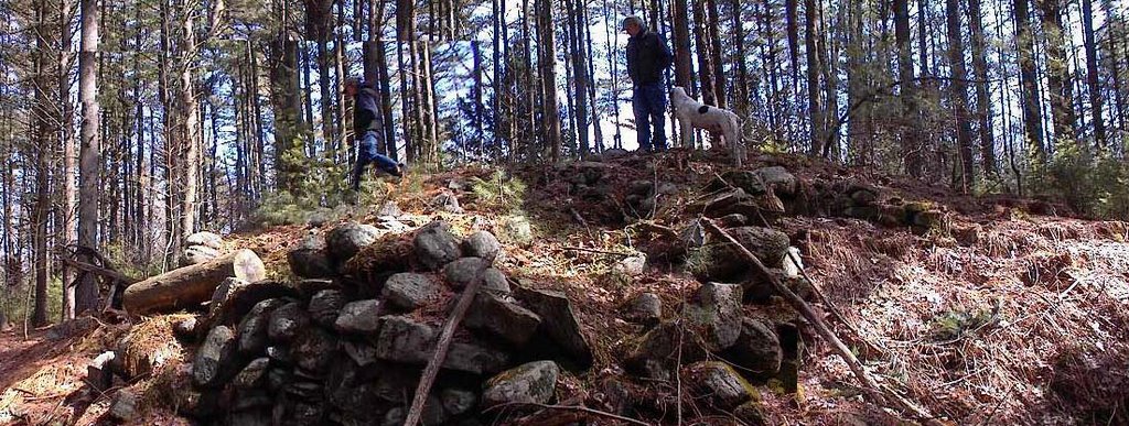 Here is a view to the south
 And a view to the west.
 A couple of points. First this pile is built in an awkward position on the sides of a gully. A couple of yards over and the pile might have been built on level ground. Secondly the side walls, where they are not too damaged, are quite cleanly built and almost vertical. This would be necessary in this awkward placement in order to make a level topped pile. Today there is significant damage to the pile, places where it has collapsed and places where it looks like a little pit was gouged into it on top. But none of the original structure would have been necessary for a boundary marker. I think it is highly unlikely that it was created for that, although it might have been used for that later. It is not currently on any known town boundary anyway. I wonder what the history book says about it?
I would like to say this pile is like the large ones we saw in Carlisle last week but it is constructed differently: it has no retaining wall and is not filled with smaller rocks. Rather is is all built from rocks of the same general size and it is almost rectangular. It has noticeable corners. Yet another style.
1 comment :
This feature reminds me of many I have seen throughout New England, particularly in Vermont, where most seem concentrated. Larry Harrop has some interesting examples posted from Parker Woodland in Conventry, RI, on his website.
Norman
Post a Comment